The BEST Views | Shuswap Edition
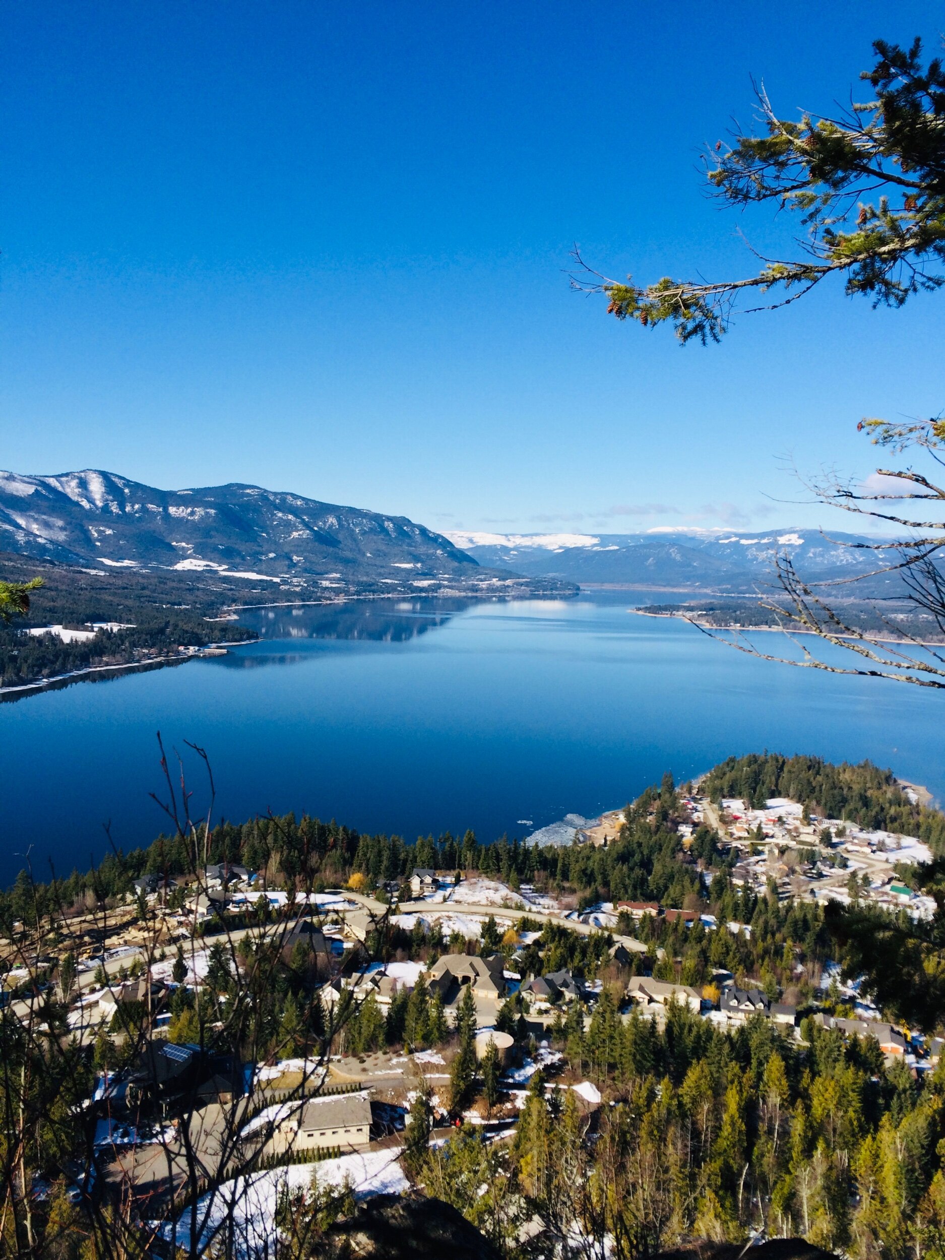
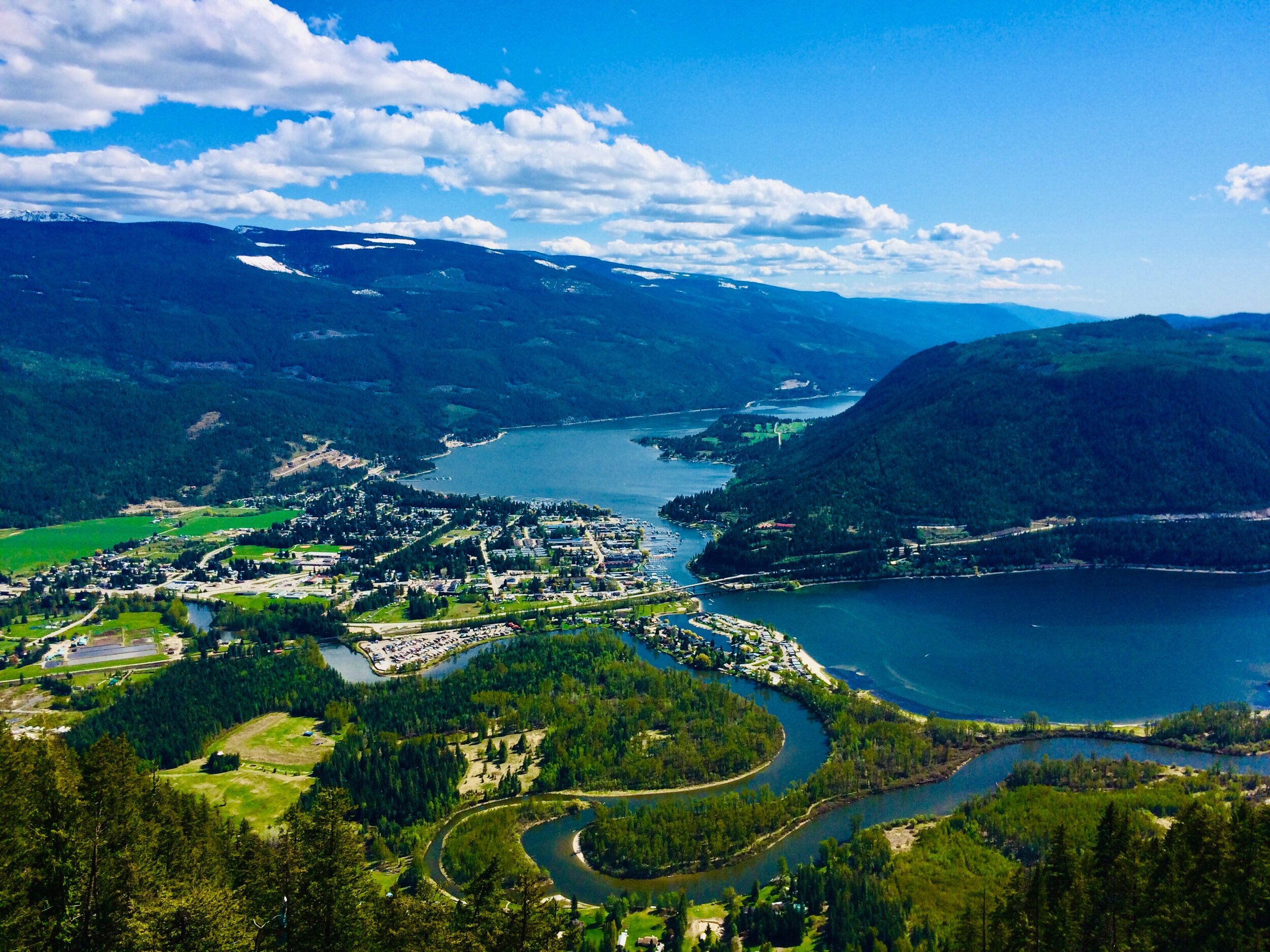
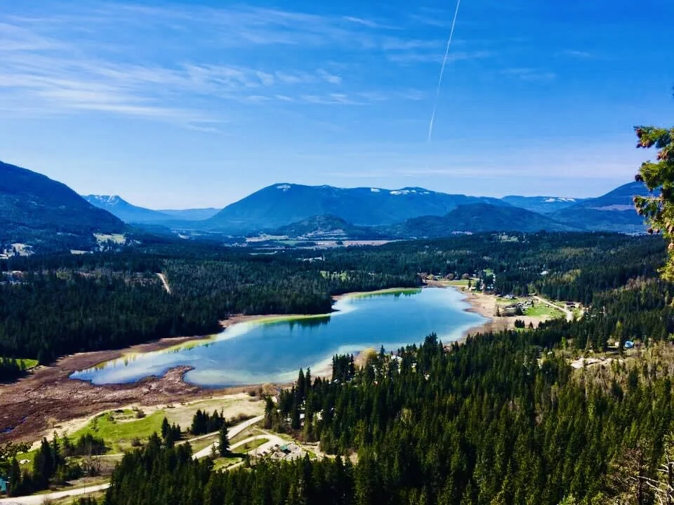
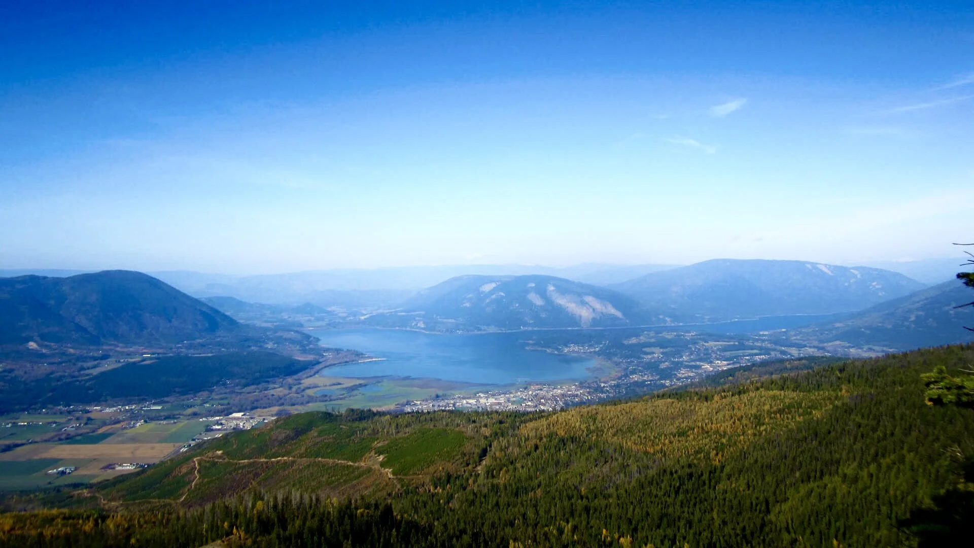
From MacArthur Heights lookout Trail, hikers can experience splendid views of Shuswap Lake. Shown here, is the subdivision of MacArthur Heights and Reedman Point below. Views West show Mount Baldy and the Adams Plateau.
Shuswap Adventure Girl
If you’re into heart-altering, far-reaching views and vistas forever then look no further! There are so many noteworthy, unusual, exciting, and daring experiences close to home that will certainly fill your soul! Fantastic places such as the varying vantage point bluffs, landmark lookouts, eagle eye cliffs, and snowscape summits encompass the Shuswap region.
The infamous peaks of the Shuswap Highlands; Crowfoot Mountain and Pukeashun Mountain are loyally surrounding you. The Monashees adorn you! Stunning views and an outstanding landscape greet you at every corner, whether it be a beautiful spot to take in the mountain air or a place to sit quietly and contemplate, the enchantment of the mountain expanse will delight your heart.
The all-encompassing Shuswap is made up of 8 unique communities within one spell bounding region. Whether it be the sunny South Shuswap, the recreational paradise of Falkland, the spirited village of Sicamous, the charming communities of Armstrong and Enderby, or the heart of the Shuswap, Salmon Arm, you can find some of the absolute BEST views that B.C. has to offer!
Grab your hiking gear, some shades, and a big open heart! Adventure awaits!
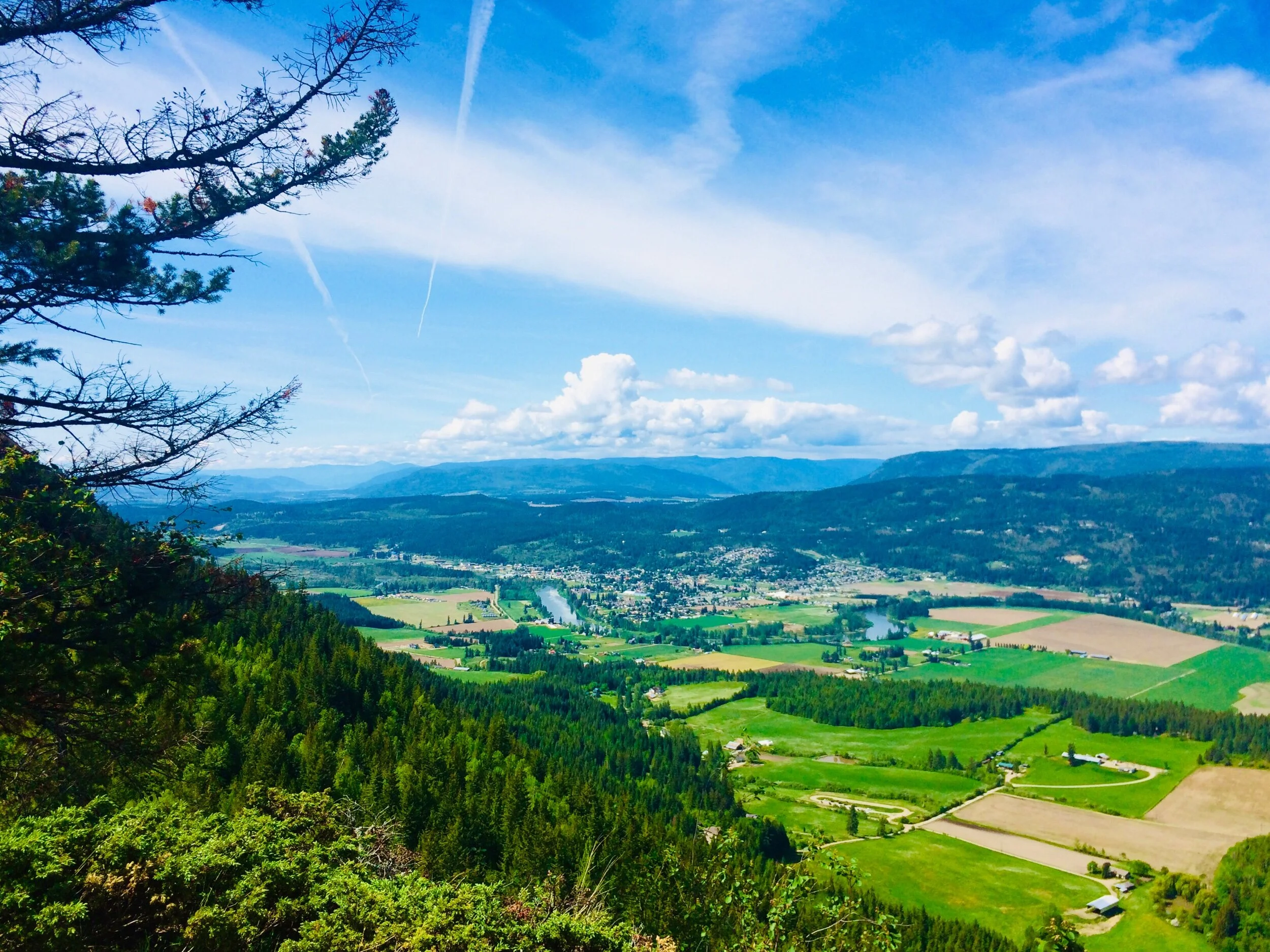
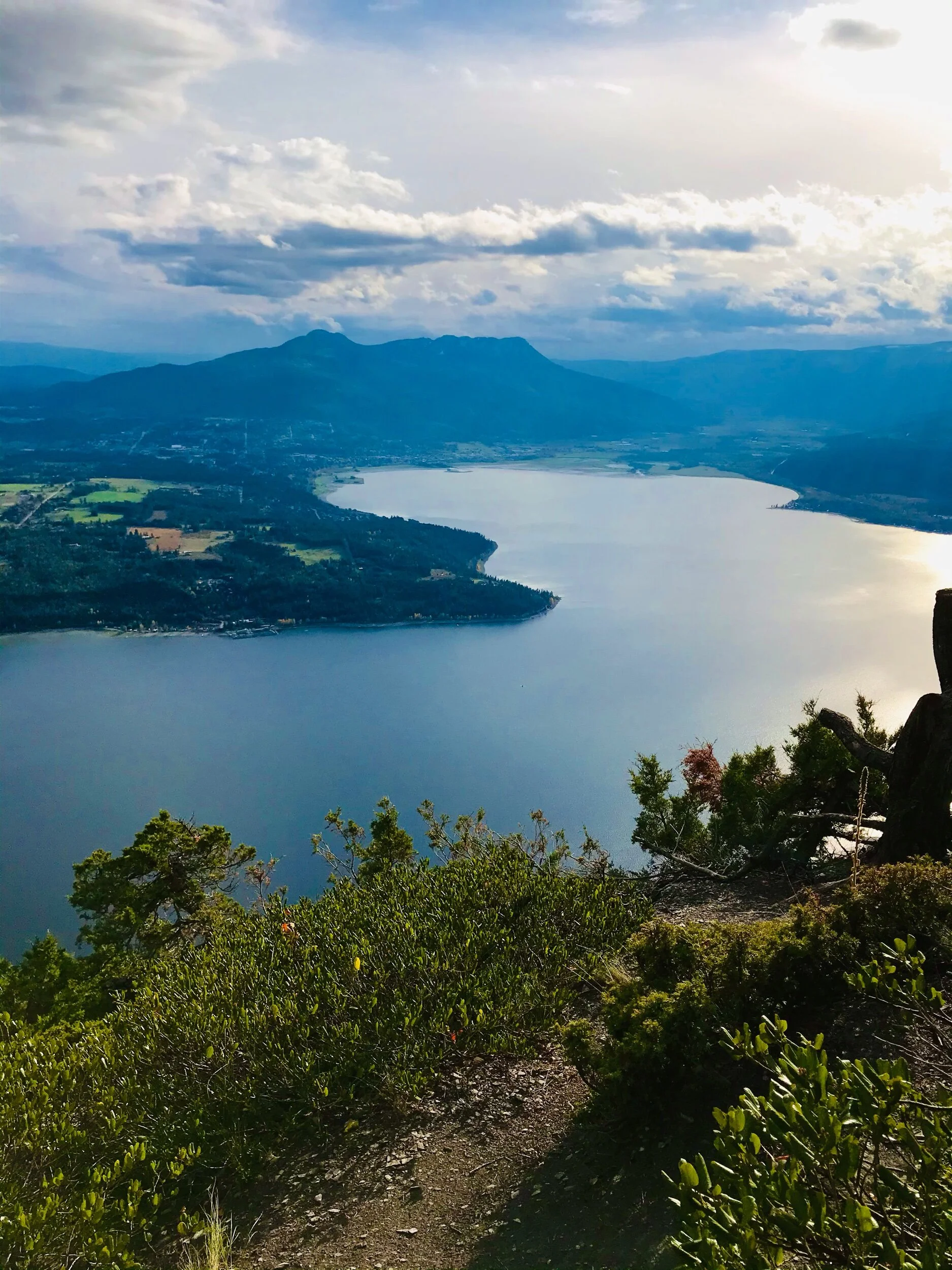
Views of the North Okanagan, and the Salmon River winding through the town of Enderby below.
Shuswap Adventure Girl
10 Best Viewpoints in the Shuswap!
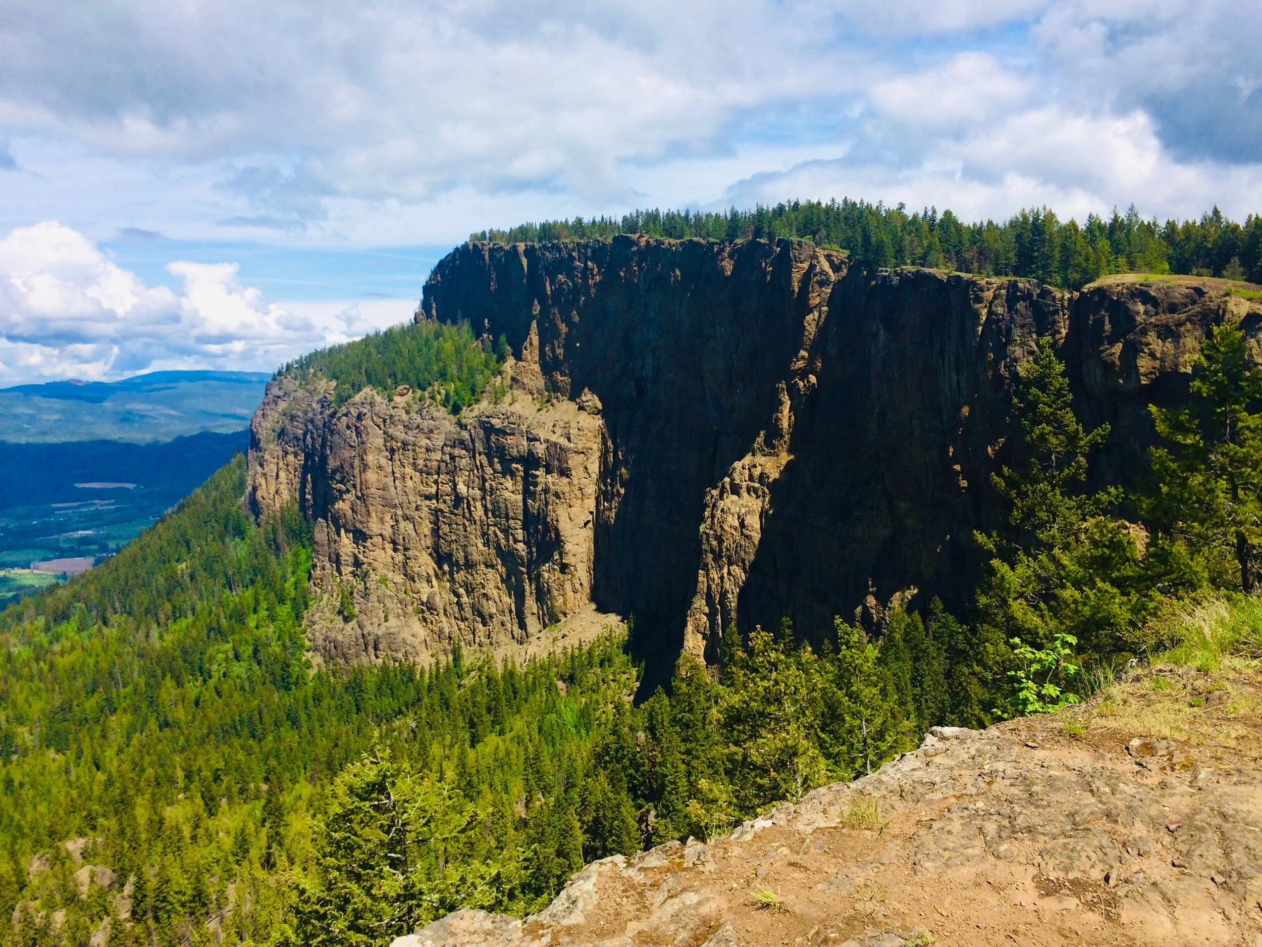
Enderby Cliffs Tplaqin Trail | Enderby
The cliffs offer a well-established trail and unforgettable journey, suitable for many levels of hikers. Adventure seekers will rejoice in the incredible and awe-inspiring Enderby Cliffs. This 13 km return hike has great rewards and is worth every bit of rigorous effort! It is known in the BC hikers circle as one of the best viewpoints in the region and is truly a special gem of the entire Shuswap! At nearly 1,200 meters high, this incredible ridge is perfectly positioned for panoramic views of the Shuswap, North Okanagan, and the Salmon River Valley.
Hikers are kindly asked to tread lightly as this is a delicate ecosystem, including volcanic rock and fossil sites.
Directions: From BC Parks website: Located 5 km northeast of Enderby. Turn East onto Mabel Lake Road. Continue for 2km down Mabel Lake Road and take a left-hand turn onto Brash Allen Road heading north. At 1.4 km, Brash Allen road forks – stay right and continue down the unpaved road for 1.6 km until you reach the parking lot on the left, which is also where the Tplaqin trail begins.
Distance: +/- 13 round trip and takes around 5 hours total, which includes lunch break at the top.
Family-Friendly: depending on the age of your kids! I know lots of kids you do go however I don’t think my 8 and 6-year-old would like the rigorous climb at this point in their hiking experience and I would be extremely nervous with them near the cliff edges.
One of the amazing views from Enderby Cliffs. Hikers can enjoy panoramic views of the Shuswap, North Okanagan, and the Salmon River Valley.
Shuswap Adventure Girl
Tappen Bluffs | South Shuswap
Tappen Bluffs has absolutely remarkable views and with relatively little effort to get there! Far-reaching vistas, as far as the eye can see in all directions highlight the breathtaking landscape of the Shuswap. Tappen Valley, Tappen Bay, Mount Tappen, Bastion Mountain, White lake, and the infamous peaks of the Shuswap highlands; Crowfoot Mountain and Pukeashun Mountain are surrounding you. Pukeashun Mountain, in the North Shuswap, is the highest point in the Adams Plateau, part of the Shuswap Highlands, sub-range being the Monashees and its parent range being the Columbia Mountains.
The short hike, with the epic finale, makes this a perfect, quick weekday morning trek or one to do with the family.
Explore more about the Tappen Bluffs here
Directions: From Salmon Arm: Follow the trans-Canada for about 14 km west of Salmon Arm, or 18 km east of Sorrento, and turn west onto Tappen Valley Rd. After approx. 4 km turn left/west onto Skimikin Lake Rd, then travel approx. 2.5 km to just past the CSRD Waste Transfer site. Turn right on the next Forestry Service Road on the right just before another bend in the road (watch for a yellow sign nailed to a tree). Park here, just off Skimikin Road if you plan to walk the FSR up. Or drive up the approx. 1.3 km to the trail, following the main FSR upwards. The route takes FSR Forestry Road #130 which starts immediately to your left and goes uphill just past the signs.
Distance: various +/- 8.5 km roundtrip from the base of the forest service road (FSR), just off of Skimikin rd. We parked approx., 2.75 km up the FSR and hiked 1.5 km to the bluffs.
Family-Friendly: Yes but keep back from steep edges, especially on the Northern side looking out towards the White Lake area.

Views from Tappen Bluffs looking out at Mount Tappen, Tappen Bay, Salmon Arm, and Bastion Mountain can be seen from here!
Shuswap Adventure Girl
Mount Rose Swanson | Armstrong
A local and visitor favorite, Mount Rose-Swanson is sure to please all levels of hikers, including the littlest! It is a great family setting to connect with nature and experience the spectacular scenery of the Spallumcheen Valley high above Armstrong! The patchwork pastures below, the blue and green variegated lakes and forests, springtime wildflowers, and the endless Shuswap skies make this panoramic vista a true treasure of the area! This trail offerers variety, hikers can choose their route and make this a 4-8 km round trip loop trail. There are several small summits along the way but making it to the radio tower on the rock bluffs is the ultimate reward. The views of the valley will knock your hiking socks right off!
A perfect adventure for the whole family and an Armstrong must-do attraction!
Directions: This is quite an interesting (and fun) drive into the trailhead! I won’t even try to explain. Follow Shuswap Trail Allinaces directions here: Mt. Rose-Swanson directions
Distance: 4-8 km round trip, there are several loop options and the trail maps are at the trailhead and at the trail junctions for easy navigation.
Family-Friendly: Yes! This trail is family-friendly. My 8 and 6-year-old manage just fine and the edges at the top are not that scary. They are not a straight drop-off like Enderby Cliffs or other infamous cliff edges around here.

Experience the spectacular scenery of the Spallumcheen Valley high above Armstrong. From the summit near the radio tower, hikers can see Otter Lake, Swan Lake, and Okanagan Lake below.
Shuswap Adventure Girl
Scotch Creek Lookout | North Shuswap
Scotch Creek Lookout is a fascinating and exhilarating journey! Head up the Scotch Creek FSR road and park at the trailhead of the Scotch Creek, Hlina Lookout. With the family, we like to head straight to the lookout and come back the same way. The views over Copper Island and towards Blind Bay are unparalleled. Imagine this hike at night? Taking in all of the beautiful “city lights” of Blind Bay across the lake? Or is that only me? Make the family day complete and explore around Lost Lake. A pretty little mountain lake tucked into the forest. Its views are worth the journey but the cliff edges can be a tad dangerous in my opinion!
Directions: The Shuswap Trail Alliance directions to the trailhead here
Distance: 3-4 km roundtrip to the lookout
Family-Friendly: Yes, younger children may require some assistance, and the edges are steep! Stay back!
The views from the Scotch Creek Lookout over Copper Island and towards Blind Bay are unparalleled. You can see all the way to Mount Ida in Salmon Arm on a nice clear day!
Shuswap Adventure Girl
Sunnybrae Bluffs | Sunnybrae Canoe Pt Rd, Tappen
Sunnybrae Bluffs is a great hiking trail that leads along the top of Raven's Bluff, offering glorious views of Tappen Bay, Salmon Arm, and Mount Ida. All along the way, beautiful views of Bastion Mountain can be seen. At the top Bastion is beside you and magnificently towers above you!
The trail is short, a little vertical in spots, and can be done with children, although there are a few places where the trail has some steep edges and youngsters may need assistance.
It is not well marked and has a variety of little trails twisting around. Once at the top, you can wander around the plateau taking in the views, or continue on approx. 5 minutes to the lush green mountainous meadow.
Directions: Parking for the trailhead is at the Sunnybrae community park and you have to cross the main road to reach the trailhead. Or if the parking lot is closed, we park at the community hall and walk the short distance on the road to reach the trailhead.
The trailhead is tricky to see! It is not marked. The trailhead is on the opposite side of the lake and starts climbing immediately. After you park, I recommend walking over to the Shuswap Tourism visitor information kiosk in the parking lot and look through the trees, directly across the main road. You will see a little trail leading you from the parking lot through the trees, across the road, and to the unmarked trailhead.
Distance: Total distance is approx. 4 km but you can spend way more time exploring around at the top of the Bluffs.
Family-Friendly: This is a kid-friendly trail IF you are ok with edges. The top is very high with a steep drop. Keep kids and pets well back! The trail also has a few steep sections and kids may need help.
We are high above the clouds over Shuswap Lake on this sunny winter’s day on Sunnybrae Bluffs! Panoramic views of Tappen Valley, Tappen Bay, The Fly Hills, Salmon Arm Bay, Mount Ida, and Canoe are incredible from this South Shuswap favorite viewpoint!
Shuswap Adventure Girl
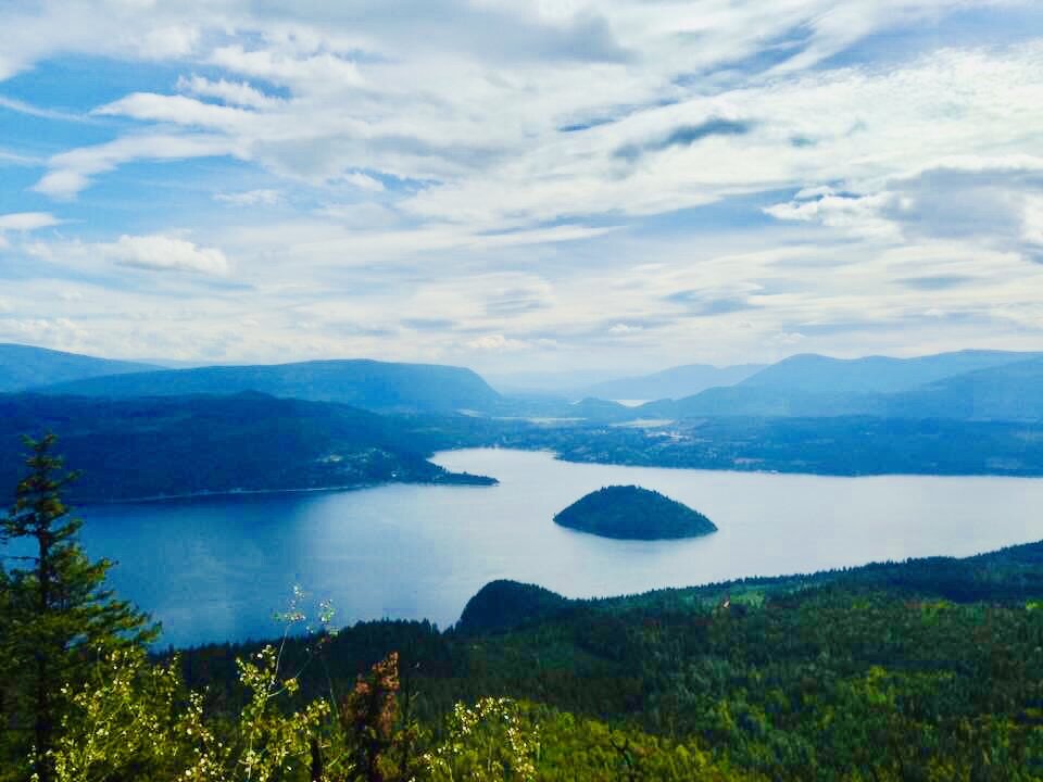
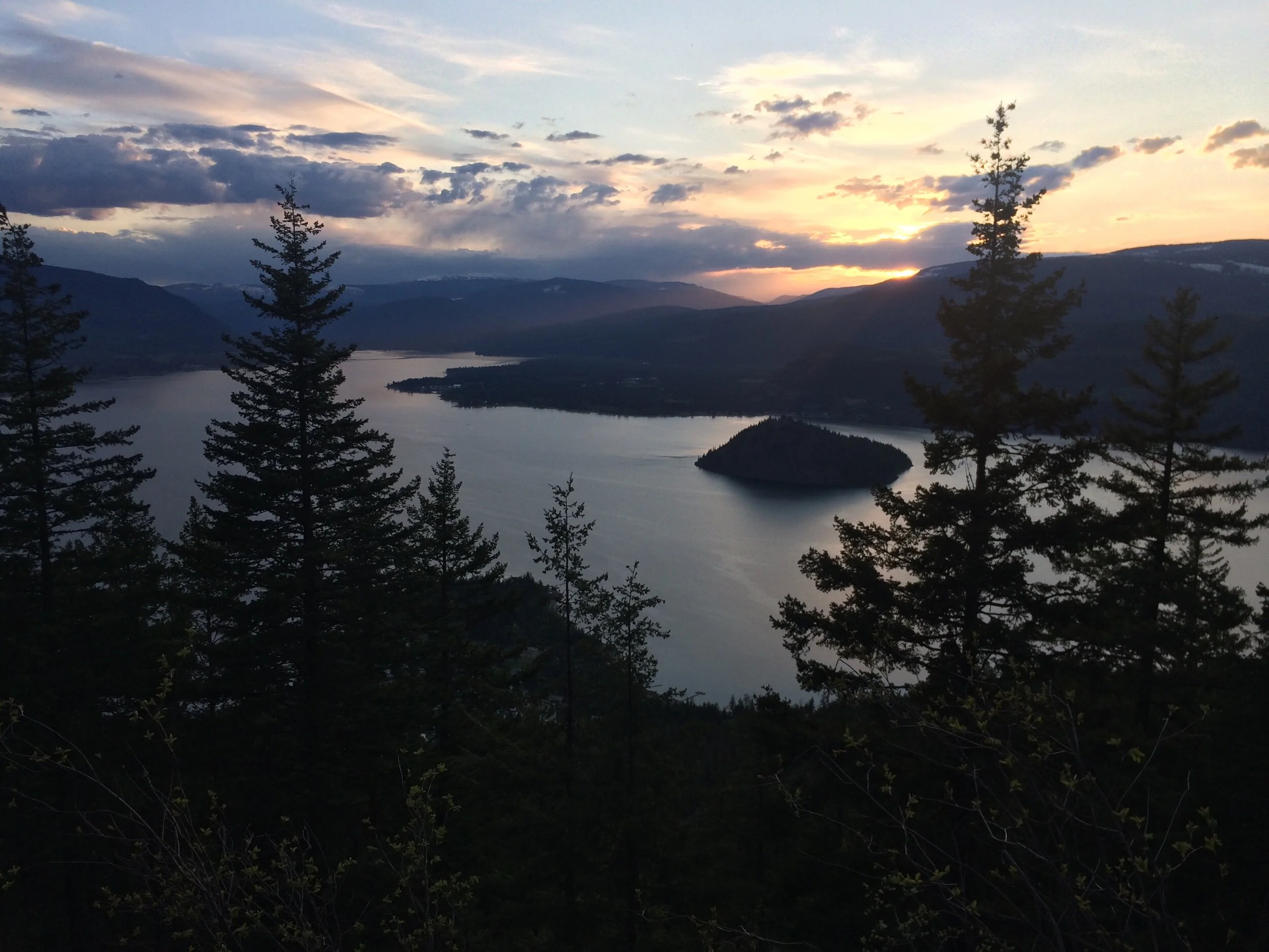
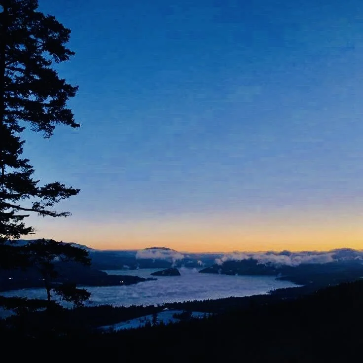
McArthur Heights Lookout | Blind Bay
An exhilarating, fun, and challenging trek in our backyard! On a clear day, you can look right over the top of Blind Bay, to Tappen Valley, and beyond to Salmon Arm and Mount Ida. To the west, breath-taking vistas of Copper Island, the North Shuswap, and even Mount Baldy can be admired! This is an epic sunset hike as the sun goes down gloriously over top of Copper Island and Scotch Creek.
The climb is rated as difficult and it is! There are a few places where the gravel is loose and careful footing is required. It provides for an excellent workout! I have a friend who runs this trail! Well worth every ounce of effort!
Explore more about MacArthur Heights Lookout and other connecting trail options here
Directions: Approximately 9km east of Sorrento or approximately 24km west of Salmon Arm turn North onto Balmoral rd. Travel north to Reedman point rd. Turn right and then take the next left onto Mcbride rd. Follow McBride all the way to the top where you will see the trailhead parking lot.
Distance: approx. 3km return
Family-Friendly: Older kids yes, I wouldn’t take my kids yet and they are under the age of 8 but I know lots of people who do take their younger children!
It is a difficult climb. The edges at the top are extremely steep and drop suddenly, however, there is adequate room to stay well back and take in those Shuswap views!
To the west, breath-taking vistas of Copper Island, the North Shuswap, and even Mount Baldy can be admired! This is an epic sunset hike as the sun goes down gloriously over top of Copper Island and Scotch Creek.
This photo is not from the true summit, you will have to experience that treat for yourself as a photo will not do it justice!
Shuswap Adventure Girl
Sicamous Lookout | Sicamous
The Sicamous Lookout is loved by locals and visitors alike, a monumental and extraordinary viewpoint! The expansive vistas of Shuswap Lake, Mara Lake, The Eagle River, Mara Mountain, the town of Sicamous are not only iconic, but they are also a must-do on your summer adventure list! The lookout was originally a hang gliders platform. It is decommissioned now but remains a top spot and absolutely represents the beauty of the Shuswap perfectly!
Although this is not really a hike, it is certainly a rewarding adventure! It can be reached by a vehicle on a Forest Service Road.
Directions: Please read accurate directions here: Shuswap Trail Alliance | Sicamous Lookout
Distance: +/- 10 km one way on FSR.
Family-Friendly: We brought our kids here but held them tightly! Extreme caution on the platform and not just for kids….adults and pets alike. The Shuswap Trail Alliance warns of rotting wood on the platform.
The expansive vistas of Shuswap Lake, Mara Lake, The Eagle River, Mara Mountain, the town of Sicamous are not only iconic, but they are also a must-do on your summer adventure list!
Shuswap Adventure Girl
Mount Baldy | Sorrento
Mount Baldy is a local favorite and for good reasons! It’s close to home, provides a gorgeous trek through a diverse forest, it is not too difficult but will challenge even a fit hiker. It has little wooden bridges and boardwalks with beautiful creek crossings. A charming and interesting sculptural art piece made of old bike parks welcomes you. The peek-a-boo viewpoint and the views at the top of Mt.Baldy will impress every time! On a clear day, northern views highlight the Adams Plateau which is part of the Shuswap Highlands, Crowfoot mountain, and Pukeashun Mountain. Copper Island, Eagle Bay, and the almost hidden entrance into Blind Bay. You also get a great view of Scotch Creek on the north shore. A local favorite! This is a great sunrise hike! Ascend in the darkness and summit just in time to watch the sun come over the mountains!
Explore more about Mount Baldy here!
Directions: Coming from Sorrento: Access the Mt Baldy trailhead by driving west of Sorrento on Highway one. Turn south onto Elson Road and drive past the unique building of Crannog Ales, then left over the railway track, and then left on South Shore Place to park in the Cul-de-Sac at the Trailhead. There is a blue and white hiking sign on the side of the road indicating where to turn to get to the parking lot. The trail starts here.
Distance: +/- 7.5 km including the 1.7 km Aspen Ramble Loop at top
Family-Friendly: Yes! Especially to the first viewpoint. This makes a great and rewarding turnaround spot if you have the kids in tow!
This is a great sunrise hike! Ascend in the darkness and summit just in time to watch the sun come over the mountains! This photo was taken close to sunrise from the first viewpoint on the ascent up Baldy. it was -24 this cold winter’s morn!
Shuswap Adventure Girl
White Lake Lookout Trail | White Lake
White Lake trail is one of my all-time favorite neighborhood hikes to do. And I bet anyone who hikes this area would say the same! The trail is short but somewhat steep, so excellent for exercise (especially when carrying a toddler on your back!). It is enjoyable with kids, with friends, as a solo hike, on snowshoes, or even on a mountain bike!
The trail climbs through a picturesque forest, passing by a creek, and offers a great small series of switchbacks. Once you reach the first lookout on the rocky bluffs you are gifted with incredible views of White Lake, Little White Lake, Tappen Valley, and Mt. Ida in the distance. All of this in a short 2 km return trip!
Explore more about the White Lake Trails here!
Directions: Approximately 9 km east of Sorrento on Hwy 1 at the Balmoral Rd junction, take first right onto White Lake Road (behind Balmoral Store). Travel to the John Evdokimoff Bike Park on your left about 7 km from the Balmoral Store on White Lake Road. Park here, the trail is clearly marked.
Distance: +/- 2 km return
Family-Friendly: Yes, caution steep edges at the first lookout and a steep, initial climb up to towers.
View from the first lookout on the rocky bluffs, where you are gifted with incredible views of White Lake, Little White Lake, Tappen Valley, and Mt. Ida in the distance.
This is Little White Lake. Amazing views of White Lake are seen from this viewpoint as well.
Shuswap Adventure Girl
Bastion Mountain Lookout | Tappen
Bastion Mountain is an iconic rock face towering above the north shore of Salmon Arm Bay, made of mostly limestone and shale. The mountain can be seen from so many areas in the Shuswap and is locally loved! People may recognize this mountain as it was previously the image on our old BC driver’s licenses. From the lookout, the far-reaching views of Salmon Arm, Salmon Bay, Canoe, Mount Ida, Flyhills, Mt.Tappen, Tappen Bay, Skimikin Valley, and Sunnybrae will keep you happily admiring for some time! An absolutely stunning scene! But be careful, those cliff edges are scary!
Explore more about Bastion Mountain here!
Directions: Directions from Salmon Arm: 15 km west of Salmon Arm on the Trans-Canada or 18 km east from Sorrento turn east onto Sunnybrae-Canoe Point Rd. Follow this road for approx. 6.5 km, turn left onto the rough gravel road marked with yellow logging road signs, leading up to Bastion Mountain. Follow the road up the mountain to the top of the cliffs near the relay tower, keeping to the best traveled main road.
Distance: 11 km forest service road with a 1 Km hike around the top
Family-Friendly: Yes and No. Depends on your comfort level. The cliff edges are very steep and the edge is sometimes hard to make out under the brush. Always keep children and pets far back. We were pretty nervous as parents up here!
From the lookout, the far-reaching views of Salmon Arm, Salmon Bay, Canoe, Mount Ida, Flyhills, Mt.Tappen, Tappen Bay, Skimikin Valley, and Sunnybrae will keep you happily admiring for some time
Shuswap Adventure Girl
Copper Island | South Shuswap
Copper Island is one of the greatest gems of the lake, as the sole island on the entire Shuswap, Copper Island is one of the pride and joys of our Shuswap life.
One of the things I love about Copper Island is the ever-changing light that embraces her. The golds and coppers gleam in the sunshine. The beautiful ecosystem that lives there, provides nesting grounds for many species and a diverse, mixed forest for us to explore. Did you know that there is a rare lily that is said to only bloom on Copper Island? Or the tale of the mermaids? (maybe not as romantic as mermaids per se, but a story of human-headed, fish-taled creatures.)
The Island has an amazing, family-friendly loop trail that provides 360-degree views of Shuswap Lake and surrounding mountains and communities. This trail is boat-in access only and there are several great spots to launch your kayak or paddleboard from to get here! It is a marked trail and there is a map at the trailhead on the north side of the island.
Copper Island is a protected park and is part of the Shuswap Provincial Park. No fires, no camping, no unnecessary treks off the trail.
Directions: Boat access only! Located in the South Shuswap
Distance: 2 km loop that takes approximately 1 hour
Family-Friendly: For sure! Our 2 year old basically hiked the entire thing herself! Just make sure to have runners on board the boat for everyone to wear on the hike. Especially in the spring when the trail has fallen trees to climb over.
The Island has an amazing, family-friendly loop trail that provides 360-degree views of Shuswap Lake and surrounding mountains and communities. This photo is looking West.
Shuswap Adventure Girl
Mount Ida | Salmon Arm
Known as the heart of the Shuswap, the lakeside community of Salmon Arm offers an abundance of soulful experiences and stunning natural surroundings in every direction! The sparkling waters of the lake entice us to live a life well-lived! Salmon Arm has many family-friendly hiking trails found within the city and nearby hills and mountains. The peaks of Mount Ida gracefully rising above reminds us that nature is always calling.
Mount Ida often awes us with its amazing and strong presence. It is rich in legend and in history. Hiking Mount Ida seems daunting and nearly impossible but it is not! There are several trails on the mountain, some of which summit to the top and provide incredible views of the Shuswap region.
The last time we hiked here was about 3 years ago but we plan to head up again this season!
We were able to drive most of the way up in our 4x4 truck on the unmaintained FSR starting East of Salmon Arm Cemetery on Foothill Road. Although I believe this now has a gate across it and is non-accessable. I’ve heard the best access is near the Silver Creek Community Park.
Directions: “The Kela7scen (Mt. Ida) East Peak Trail is accessed from the Mount Ida North Trailhead. The hike up to the East peak is a steep climb with switchbacks through the forest. From the forest the trail will start to level off more and approach the spine of the mountain. After a walk along the spine with steep drop offs on either side of the trail you approach the first viewpoint offering a stunning 360 degree view of Salmon Arm, Salmon River Valley, and Deep Creek area. If you continue on you will come to a second viewpoint with a stunning view of the Salmon Arm area. To get to the second viewpoint there is a short section with an exposed rock scramble.” From the Shuswap Trail Alliance website. Read more here: https://shuswaptrails.com/trails.php?area=0&id=47
Distance: Various, plan for a day trip!
Family-friendly: This is solely up to you, it is defiantly dangerous up there and the scramble is difficult. That being said, we did it with a toddler being packed on my back. And we plan to take our elementary-aged kids up this season as well as a toddler on my back.
Views from Mount Ida looking down at Salmon Arm, Salmon Bay, Bastion Mountain and Mt. Tappen
Shuswap Adventure Girl
Want to Explore more?
Other MUST-DO’s in the Shuswap Region!
Mountain Edition
These options are a little more difficult and may be classified as intermediate to expert hiking abilities. Personally, I have not completed all of these jaw-droppers, however, I plan to this coming hiking season(s)! This summer, as a family, we are planning to journey and discover the old fire lookouts of this area and surrounding areas, for they have the best standpoint! Stay tuned and happy trails!
Falkland
Estekwalan Mountain
Tuktakamin MountainSicamous
Eagle Pass Lookout Twin Lakes
Hyde Mountain Lookout, Joss Mountain
Mara Mountain.The North Shuswap
Crowfoot Mountain and Mobley Lookout
Pukeashun Mountain